
Quick summary
Landmannalaugar offers unparalleled aerial photography opportunities with its vibrant rhyolite mountains and mystical hot springs. This guide reveals top sites like Thorsmork and Eldgja to help you capture stunning images from Iceland's dramatic high
Landmannalaugar is not just a destination; it's a journey into a world where nature's artistry is on full display. The rhyolite mountains, with their vibrant colors, seem to dance under the shifting light, making aerial photography in Landmannalaugar a must.
The steam from the hot springs adds a mystical quality to the landscape, while the expansive highlands stretch out, offering a canvas of dramatic and diverse beauty. For aerial photographers, every flight over Landmannalaugar is an opportunity to capture a unique masterpiece, a moment where nature's grandeur is frozen in time.
Landmannalaugar, a photographer's paradise nestled in Iceland's southern Highlands, is a destination that transcends the ordinary. Its vibrant rhyolite mountains, steaming hot springs, and dramatic landscapes offer countless opportunities to capture stunning images that are unparalleled in their beauty and diversity.
7 Must-see aerial photography destinations in the Icelandic Highlands
Thorsmork (Þórsmörk Nature Reserve)
Known as the 'Valley of Thor,' this area is located in the south of Iceland, nestled between the Tindfjallajökull and Eyjafjallajökull glaciers. Thorsmork is a lush oasis featuring a rich variety of geological formations, green moss, ferns, birch trees, and winding glacial rivers. It's a popular hiking area, offering diverse compositions for photography, including wildlife like the Arctic fox

The valley is warmer than the rest of the south coast, often shrouded in mist or fog, adding to its mystique. The area is accessible via several hiking trails, including a route to the peak of Valahnúkur mountain for a panoramic view.
See Thorsmork ToursEldgja (The Fire Fissure)
Eldgja is a volcanic canyon located in the south of Iceland, stretching 40 kilometers long and about 600 meters wide. It's the largest volcanic canyon in the world, formed during a basaltic flood lava eruption in 939. The canyon is known for its 200-meter-high cliffs and Ófærufoss, a stunning two-tiered waterfall. Eldgja offers spectacular views for long exposure and aerial photography, especially in the summer.

Haifoss
Near the Hekla volcano, Haifoss is the fourth-tallest waterfall in Iceland, with a drop of 120 meters. Originating from the river Fossá, it flows into Þjorsá, Iceland's longest river. The waterfall, surrounded by colorful vegetation and wildflowers, is particularly photogenic during summer and autumn. Nearby is the Granni waterfall, offering excellent opportunities for panorama photography.

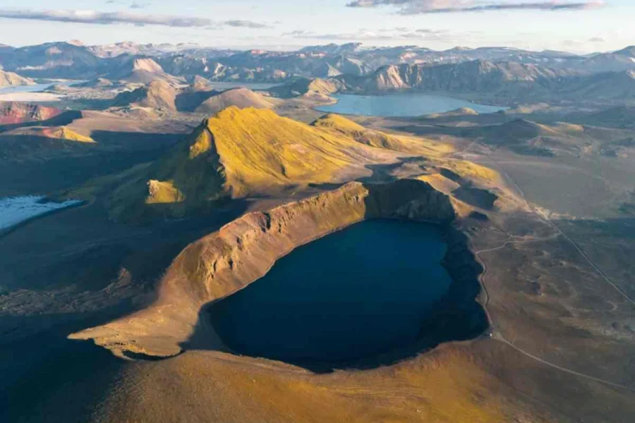
Blahylur & Ljotipollur
These are two stunning crater lakes in the central Highlands. Bláhylur, also known as ‘Hnausapollur,’ is known for its vivid blue water, while Ljótipollur, meaning ‘the ugly puddle,’ features impressive red slopes contrasting with sparkling water. These craters are excellent for panorama, wide-angle, and aerial photography, especially during sunset.
Landmannalaugar
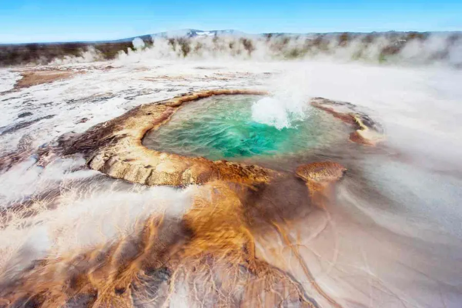
This area is part of the Fjallabak Nature Reserve in the southern Highlands. Known for its colorful rhyolite mountains, steaming hot springs, and expansive lava fields, Landmannalaugar is a photographer's paradise. The area offers a variety of trails and compositions, with the mineral-rich slopes providing a magical tone to photos. It's best visited in summer, and there's a natural geothermal bathing pool at the campsite.

Kerlingarfjoll & Hveravellir
The Kerlingarfjöll mountain range is a geothermal area in the central Highlands, featuring steaming rivers, hot springs, and fumaroles. The rhyolite mountains provide amazing vantage points for photography. Hveravellir, located between the Langjökull and Hofsjökull glaciers, is a hot spring area with boiling aquamarine springs surrounded by multicolored sinters and cracked mud.
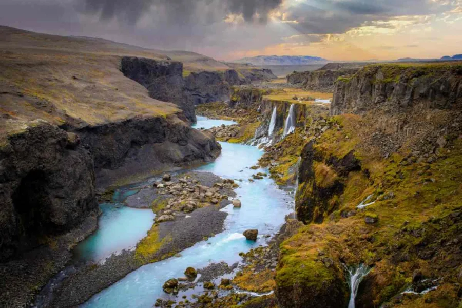
Sigoldugljufur (Valley of Tears)
This moss-covered canyon is a hidden treasure in Iceland, where numerous waterfalls flow over steep cliffs into a blue river below. Known as ‘Lekafossar,’ these waterfalls offer stunning photo opportunities, especially under the Midnight Sun. The area is off the beaten track, offering a unique and serene photography experience.
The Colorful Tapestry of Landmannalaugar
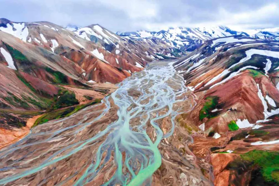
Landmannalaugar's unique appeal lies in its colorful rhyolite mountains. These mountains are a geological marvel, showcasing a spectrum of colors from yellows, reds, greens, to purples and blues. The colors result from the presence of different minerals, such as iron, sulfur, and copper, which paint the mountains in these vibrant hues. The shifting light of day plays with these colors, creating a dynamic and ever-changing landscape that is a dream for aerial photographers.
Geological Wonders: The Making of Landmannalaugar
The geology of Landmannalaugar is as fascinating as its colors. Formed through centuries of volcanic activity, the area is a testament to Iceland's fiery heart. The rhyolite mountains, formed from the cooling of magma, are not just visually stunning but also tell a story of the Earth's inner workings. This geological diversity, including lava fields and hot springs, adds layers of depth to aerial photography, offering a glimpse into the raw power of nature.
Staying in Landmannalaugar: Embracing the Wilderness
For those wishing to immerse themselves fully in the Landmannalaugar experience, staying in the region is possible. The area offers camping grounds and mountain huts, providing basic but comfortable accommodations. Staying overnight allows photographers to capture the magic of the Midnight Sun or the ethereal Northern Lights, adding another dimension to their aerial photography portfolio.

The Majestic Landmannalaugar Mountains
The Landmannalaugar Mountains, part of the Fjallabak Nature Reserve, are a central attraction. These mountains, with their unique coloration and rugged terrain, are a highlight for any aerial photographer. The panoramic views from the peaks, accessible by hiking, offer a breathtaking perspective of the Icelandic Highlands, showcasing the vastness and untouched beauty of this remote area.
Frequently asked questions about aerial photography in Landmannalaugar
Why is Landmannalaugar colorful?
Landmannalaugar is known for its colorful landscape, primarily due to its geology. The area is rich in rhyolite, a type of volcanic rock that contains a variety of minerals. As these minerals oxidize, they produce a range of vibrant colors, including yellows, reds, greens, blues, and purples. The colors can change and intensify depending on the light conditions, making the scenery exceptionally striking and varied.
What is the geology of Landmannalaugar?
The geology of Landmannalaugar is predominantly characterized by rhyolite and obsidian formations. Rhyolite is formed from volcanic eruptions and is known for its rich mineral content, which contributes to the area's colorful mountains. The presence of obsidian, a natural volcanic glass formed from rapid cooling of lava, adds to the geological diversity. The area also features extensive lava fields, hot springs, and geothermal activity, all indicative of its volcanic origin.
Can you stay in Landmannalaugar?
Yes, you can stay in Landmannalaugar. The area offers a camping site where visitors can pitch tents during the summer months. Additionally, there are mountain huts available for rent, providing a more sheltered accommodation option. These facilities typically include basic amenities and are popular among hikers and nature enthusiasts. It's important to book these huts in advance due to their limited availability.
Where are the Landmannalaugar Mountains?
The Landmannalaugar Mountains are located in the southern part of Iceland's Highlands. This region is renowned for its stunning landscapes and is part of the Fjallabak Nature Reserve. Landmannalaugar is accessible via the Icelandic Ring Road and then by mountain roads, which are best navigated with a 4x4 vehicle. The area is a popular starting point for the famous Laugavegur hiking trail and is known for its natural geothermal hot springs and breathtaking hiking routes.


